Georgia Surveyors Exchange
Support Beyond The Sale
GPS
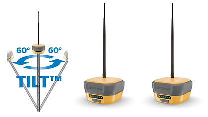
Topcon HiPer XR GNSS RTK Base and Rover


For surveyors and construction professionals who need to measure those hard-to-reach points, the HiPer XR is your ultimate solution. This lightweight GNSS receiver offers dependable performance, featuring improved signal integrity, precise tilt accuracy, and versatile communication options.
Features:
-
Calibration-free and immune to magnetic disturbances TILT-technology up to 60 degrees
-
The HiPer XR stands out with its anti-jamming and anti-spoofing capabilities. Its advanced interference mitigation ensures you can collect data even in challenging conditions.
-
Supporting multiple constellations (GPS, GLONASS, GALILEO, BeiDou, QZSS, IRNSS, SBAS) for unparalleled reliability and precision.
-
Fully Integrated Receiver with a GNSS antenna, batteries, communications, and memory.
-
Supports the Hybrid workflow.
-
Battery Life: with over 7 hours of operation time at 1W transmission as a base and more than 10 hours as a rover, coupled with fast charging capabilities (50% capacity in just 40 minutes) using the universal USB-C port.
-
The integrated LongLink Bluetooth communication ensures a radio-free and most flexible connection between base and rover up to 300m.